GPS ART
About
GPS helps those artists to measure the world with their bodies, leaving traces of their presence and conveying their relationship to the environment. The process of locating, tracing and marking through the use technology also gives them a way to exert dominance and control over the environment but in a sustainable way. These GPS artworks are part of the walking history and are closely related to the history of walking art of the past. Through these artists’ walk, we can see some surrealistic aspects and some contemporary aspects of the situationist. GPS as a creative medium creates walking art using the presence of the body rather than using the absence of the body as with previous walking artworks like Richard long's work A line made by walking in 1967.
YUWEN
2023.05


Jeremy Wood
Traverse Me
2010
http://www.gpsdrawing.com/maps/traverse-me.html
Jeremy Wood used a GPS to record his path when he walked around the university campus and created a new map of it. He was not only guided by roads and paths, but also walked around unmarked areas to create his own “drawing” for inspiring people to think about the possibility within these landscapes. He sees his body, especially through walking, as a geodesic pencil to create artworks and GPS as his rendering tool to form his personal narrative
Stephen Lund
A great big owl with teeny-tiny feet
2018
Stephen Lund is also a contributor to GPS art, even though his work is not really based on walking. He is cyclist and a GPS artist. In his GPS art, he mounted his GPS on bike as a tool to create his sketch of his city. Before starting a project, he would glance at a map and catch inspiration from it to gain a mental sketch in his mind.


Yasushi Takahashi
Marry me
2008 (Japan)
The most massive GPS artwork was created by Yasushi Takahashi as a marriage proposal. It was recognized by the Guinness Book of World Records and it is about 7.163km long. His creative process is different from others, though he still uses GPS to make art. The artists mentioned above are more or less influenced by urban planning routes and landscapes, so they make compromises with the city and the environment around them. But in Yasushi’s artwork, he creates a precise image in his mind and needs to perform this practice accurately across the island of Japan. The environment cannot be a limitation for his movement.
GPS Art has promoted the creation and development of sports analytic software, like Strava, Run Club and MapMyRide Using an athlete’s route across the landscape to create digital drawings is particularly popular on Strava, so it is often referred to as “Strava art.” Janine Strong, a GPS artist, completed and uploaded a digital version of “Girl With a Pearl Earring” 357 years after Johannes Vermeer completed his masterpiece "Girl With a Pearl Earring" in 1665. On her website, we can see other GPS sketches which she uploaded via the app.
Janine Strong
Girl With a Pearl Earring
2022
77.2km(47.95miles) ride with 324m (1,064 ft) elevation gain, Brooklyn, NY
https://www.janinestrong.com/copy-of-photography


Plan B (Sophia New and Daniel Belasco Rogers)
All Journeys in Berlin
2003 – 2012
(ten-year drawing) https://planbperformance.net/works/lifedrawing/
There is an artistic duo called Plan B (composed of members Sophia New and Daniel Belasco Rogers), who make GPS art as a way to express ethical problems like the possibility of a vision of the future where technology is controlled. They see GPS tracking data as personal data, reflecting habits and information about a person's personal life. Through collecting their GPS trace data and turning their entire years of traces into an exhibition, they effectively make every action they had taken accessible public knowledge. This makes the point that this innocuous walking activity can also be used for personal information trafficking.
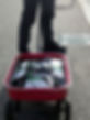
Simon Weckert
Google Maps Hacks
2020
Simon Weckert, a Berlin-based artist, created Google Maps Hacks in 2020. His work hacks the GPS's reading of the city’s system. Based on the interactive features within Google Maps, normally, Google Maps shows the road condition using different color lines to reflect the traffic conditions. To produce the artwork, 99 secondhand smartphones were transported in a handcart to generate a virtual traffic jam in Google Maps. This activity misled other cars to drive different routes to avoid being stuck in traffic.